Showing 6 items matching the old sand hill
-
 Eltham District Historical Society Inc
Map (item) - Sales Brochure, Plenty Township Estate and Bryn Teg Hill's Estate, Coghill & Haughton, Melbourne, c.1924
... the old sand hill... as "The Old Sand Hill, "within walking distance of the Montmorency... stations." Bryn Teg Hill's Estate "Better known as "The Old Sand ...Plenty Township Estate "The rapid growth of Greensborough and the great traffic development on the main road between Heidelberg and Eltham augurs well for Plenty Township Estate. Already a Store, Post Office and State School have been started, and the activities of the Local Progress Association will help the district forward considerably. Within walking distance of the Montmorency and Greensborough stations." Bryn Teg Hill's Estate "Better known as "The Old Sand Hill, "within walking distance of the Montmorency and Greensborough railways stations." "Some few years back Mrs Thomas subdivided portion of the Sand Hill Paddocks, and the areas sold have been settled and many converted into charming outer suburban garden homes with cultivation and orchard plots. The south-eastern slope gives the land a grand outlook over the Yarra Valley on to the Dandenoings, and the are is very picturesque and homely." "A number of the blocks contain large deposits of valuable building sand, which should prove good speculation in view of the forecast for further rapid home development along the Eltham Suburban Electric Service." Sand Hills Road (Old Eltham Road) Date estimated as c.1924 - Electricification of railway line to Eltham referenced on map occured April 1923 and Mrs Mary Thomas died August 1925. Her home Bryn Teg became part of the Heidelberg Golf Club in 1927.The establishment of Lower Plenty as a suburban growth area supported by easy commuting facilitated by the elctrification of the Eltham railway linebonds road, bridge, bryn teg hill's estate, coghill & haughton, eltham road, heidelberg golf club hotel, houses, lower plenty, lower plenty bridge, lower plenty road, main road, plenty hotel, plenty river, plenty township estate, real estate agent, sales brochure, sand hills road, the old sand hill, sand hill paddocks, woodfull road, old eltham road, bryn teg, mrs m thomas -
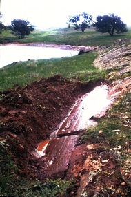
 Wycheproof & District Historical Society Inc.
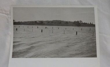
Photograph, Mr Ernie Taylor, Cooroopajerrup Creek 1923, 1923 (exact)
The semi-mythical stream, the Cooroopajerrup Creek. Before there were any channel banks and formed roads, this creek shared the Avoca flood waters with the Tyrrell Creek. In more recent times the Wycheproof channel prevented the major floods of 1956 and 1973 from following the old river course. Also there is said to have been some shifting of the sand-hills at Teddywaddy which have blocked much of the old Cooroopajerrup flow. Little is known of earlier records, but The Mount Wycheproof Ensign records flooding of the creek in 1909. 2011 saw the Cooroopajerrup flow again after 88 years. This 2011 photo was taken at about the same position as the 1923 photo. The modern steel roadway fence is submerged. see-Photograph-Record No 001997.Copy of a B&W photograph of the Cooroopajerrup-Creek in flood-1923. To the north is Mount-Wycheproof, with the hospital barely visible behind the trees just left of centre, and a few scattered dwellings. The nearer railway-fence follows the road leading to the current saleyards.The outer fence has been replaced with a modern steel fence.None1923, cooroopajerrup creek, flood, mount wycheproof -
 Flagstaff Hill Maritime Museum and Village
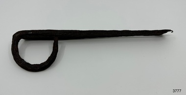
Functional object - Latch, before 1890
In Flagstaff Hill’s collection are items associated with the Ancient Wreck, (also called the Gold Ship, Mahogany Ship or Ancient Vessel). Three relics were located in 1890, due to the ‘interest of a public works inspector, James Gilroy, who dug in the ship’s remains’. One of the relics was a heavily oxidated ‘quantity of ironwork’. The other two, now part of Flagstaff Hill’s collection, are - an iron latch probably from a galley oven door or fireplace - a bronze bolt (spike or pin) Both of these relics are listed on the same page in the records of the Old Warrnambool Museum, found by K.A.G. (or H.A.G.) on the site of the Ancient wreck in 1890. Interestingly, another item in these records is ‘Notes on Ancient wreck, near Gorman’s Lane’. Gorman’s Lane is just inland from the sand dunes of the Coastal Reserve at Tower Hill. The current location of these Notes is unknown. Another item thought to be a relic from the Mahogany Ship was the amphora or jug, also in Flagstaff Hill's collection. It was found in 1934 on a local property and donated in 1985. The Museum opened in 1886 and continued until 1963, when it was closed by the Warrnambool City Council and the whole collection was put into storage. The council then transferred items to various places including Flagstaff Hill and the current Warrnambool Art Gallery. Flagstaff Hill’s early Accession Records book lists the items as being received from the Old Warrnambool Museum collection; the Latch is record 152 and the Pin is record 153. An article, ‘Birthplace of our History’ by Don Dean, is on file in the Warrnambool and District Historical Society. It was published in the Australian POST, on March 17, 1955. This article describes the finding of the items going back to 1890, along with other information about sightings of what has come to be known as the Mahogany Ship. The mystery of the Mahogany Ship began in 1836 when two shipwrecked sealers discovered the remains of an “ancient vessel” in the sand dunes about four miles west of Warrnambool. Since the last recorded sightings in the 1880’s the true origin of the Mahogany Ship has remained one of Australia’s most famous historical mysteries. One of the more recent theories is that the vessel was one of the Portuguese ships exploring the Australian coast in 1522. For over one hundred years searchers have attempted to locate and identify the wreck. The search continues for the tangible evidence which will once and for all establish the Mahogany Ship’s place in Australia’s History. The latch has local historic significance as it was found in the sand dunes of Warrnambool in 1890. The latch is also significant for being part of the original 1886 Warrnambool Museum's collection. The latch is significant for its possible link to one of Victoria’s and Australia’s maritime mysteries, the Mahogany Ship (also known as the Ancient Wreck). It is one of very few known relics that could give evidence of the existence and history of the vessel. It is listed on the Victorian Heritage Register S438 as it is one of Victoria’s oldest recorded shipwrecks. The identity of the vessel has the potential to change Australia’s history.Latch, iron. Flat iron latch tapers inward from loop handle to narrow end with prongs. Handmade. warrnambool, shipwrecked coast, flagstaff hill maritime museum, shipwreck coast, mahogany ship, latch, relic, old warrnambool museum, ancient vessel, ancient wreck, oven latch, fireplace latch, galley oven, gold ship, gorman's lane, coastal reserve, tower hill -
 Flagstaff Hill Maritime Museum and Village
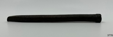
Functional object - Bolt, before 1890
Flagstaff Hill’s collection has items that are thought to be relics from the Ancient Wreck, (also called the Gold Ship, Mahogany Ship or Ancient Vessel). Three relics were located in 1890, due to the ‘interest of a public works inspector, James Gilroy, who dug in the ship’s remains’. One of the relics was a heavily oxidated ‘quantity of ironwork’. The other two, now part of Flagstaff Hill’s collection, are - an iron latch probably from a galley oven door or fireplace - a bronze bolt (spike or pin) Both of these relics are listed on the same page in the records of the Old Warrnambool Museum, found by K.A.G. (or H.A.G.) on the site of the Ancient wreck 1890. Interestingly, another item in these records is ‘Notes on Ancient wreck, near Gorman’s Lane’. Gorman’s Lane is just inland from the sand dunes of the Coastal Reserve at Tower Hill. The current location of these Notes is unknown. Another relic is thought to be the amphora, discovered in 1934 on a local property. The Museum opened in 1886 and continued until 1963, when it was closed by the Warrnambool City Council and the whole collection was put into storage. The council then transferred items to various places including Flagstaff Hill and the current Warrnambool Art Gallery. Flagstaff Hill’s early Accession Records book lists the items as being received from the Old Warrnambool Museum collection; the Latch is record 152 and the Pin is record 153. An article, ‘Birthplace of our History’ by Don Dean, is on file in the Warrnambool and District Historical Society. It was published in the Australian POST, March 17, 1955. This article describes the finding of the items going back to 1890, along with other information about sightings of what has come to be known as the Mahogany Ship. The mystery of the Mahogany Ship began in 1836 when two shipwrecked sealers discovered the remains of an “ancient vessel” in the sand dunes about four miles west of Warrnambool. Since the last recorded sightings in the 1880’s the true origin of the Mahogany Ship has remained one of Australia’s most famous historical mysteries. One of the more recent theories is that the vessel was one of the Portuguese ships exploring the Australian coast in 1522. For over one hundred years searchers have attempted to locate and identify the wreck. The search continues for the tangible evidence which will once and for all establish the Mahogany Ship’s place in Australia’s History. The bolt has local historic significance as it was found in the sand dunes of Warrnambool in 1890. The bolt is also significant for being part of the original 1886 Warrnambool Museum's collection. The bolt is significant for its possible link to one of Victoria’s and Australia’s maritime mysteries, the Mahogany Ship (also known as the Ancient Wreck). It is one of very few known relics that could give evidence of the existence and history of the vessel. It is listed on the Victorian Heritage Register S438 as it is one of Victoria’s oldest recorded shipwrecks. The identity of the vessel has the potential to change Australia’s history.Bolt, also referred to as spike or pin. Bronze bolt, round body with head on one end that has straight sides, tapers to a point at the other end.warrnambool, shipwrecked coast, flagstaff hill maritime museum, shipwreck coast, mahogany ship, relic, pin, spike, old warrnambool museum, nail, ancient vessel, ancient wreck, portuguese ship, gold ship, gorman’s lane, coastal reserve, tower hill -
 Flagstaff Hill Maritime Museum and Village
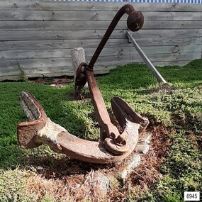
Equipment - Anchor, John Trotman, 1852 to early 1900s
This Trotman’s pattern stock anchor is the southernmost anchor on display at Flagstaff Hill’s Anchor Graveyard. This large Trotman design anchor was patented in 1852 by John Trotman and was widely used on merchant ships. On April 15th 2001 around midday this anchor was raised from the seabed of Lady Bay, Warrnambool, by the crew from Birdon Dredging, who had been hired to dredge the Harbour. The spokesperson Steve Walker, who worked for the firm, said that the anchor and long chain were found after the chain became tangled in the cutter blade of the dredging equipment. The anchor was lifted from the water and onto the Breakwater then a front-end loader placed it onto a truck that then delivered it to Flagstaff Hill Maritime Museum & Village. Howard Nichol, Museum Manager at the time, had estimated the anchor to be up to 130 years old. The previous Museum Manager, Peter Ronald, who was also a diver, had identified the anchor as a Trotman’s type and similar to those used on some of the major wrecks in the region. According to Nicholl, Museum staff believed it was possible that the anchor is one of two used as a mooring line that had been used to catch driving vessels and prevent ships from washing aground on the sand bar. The mooring line was shown as a dotted line on the 1890 chart of Lady Bay, approved by Lieutenant Stanley of the British Admiralty. by Lieutenant Stanley [British Admiralty]. The location of the anchor corresponds to a point on that map and the length of the chain supports that theory. “The map is quite a detailed survey of the Bay and it shows two anchors with buoys on the ends with probably about 100 yards of chain stretched between them. The ships would drop anchor and was the chain as a snag because this was a treacherous bay before the Breakwater was built and this was a way to eliminate that problem, "said Nichol. The mooring chain was put in place to catch drifting vessels during wild stormy weather. It was identified. ABOUT TROTMAN’S ANCHORS- The British Admiralty wanted an anchor design that had more holding power. The Committee of 1852 on Anchors was appointed to assess and report on the qualities of various anchors including Trotman’s anchors. Trotman’s pattern anchor received the highest score. The anchor is similar to the Admiral’s design but features arms that pivot when the anchor settles and the upper fluke moves to rest against the shank. The anchor then sits lower, which in turn greatly reduces the chances of the anchor’s chain, cable or rope getting tangled. The top of the shank has a fitting that allows a quick release of the anchor’s chain if this becomes necessary. This Trotman’s anchor is significant as a part of the maritime history of the Port of Warrnambool regardless of whether it belonged to one of the 29 ships that were stranded or wrecked in Lady Bay. The anchor is connected to the many attempts to maintain Warrnambool as a safe and manageable port, including the various plans for the construction of the Breakwater.Anchor: an iron Trotman’s pattern style with a rectangular-section shank that is wider in the middle and has a base that extends on two opposite sides in a ‘fork prong’ manner. A crescent-shaped, double-ended arm is fitted into the base of the shank with a bolt, enabling it to pivot. Each arm has a fluke in the shape of an upward palm with an attached metal plate that forms a horn at the back of the palm. A long, round-section pipe is fitted to the top of the shank at 90 degrees to the arms; one side has an elbow bend parallel to the arms, and both ends have an attached metal sphere. The pivoting ring at the top of the shank can be lifted for a quick release of the chain.flagstaff hill, warrnambool, maritime village, maritime museum, shipwreck coast, great ocean road, anchor, mooring, trotman, lady bay, breakwater, admiralty, ship equipment, stock anchor, john trotman, 1852 patent, 2001, birdon dredging, steve walker, howard nichol, peter ronald, british admiralty, lieutenant stanley, committee of 1852 on anchors -
 Bendigo Historical Society Inc.
Slide - Dunn's Rock Eppalock, 2012
The low rolling hills of the Kimbolton countryside consist of ancient, hard and fractured Ordovician rock up to 65 million years old, which was originally deposited deep under the sea. Rocks mainly are sandstone, mudstone, black shale and quartz conglomerates. Marine fossils can be found in the area. Around seven million years ago a basalt flow buried the original bedrock along the along the Campaspe River. Ongoing weathering, wind and water movement over the following years has produced younger clay, sand, silt and gravel deposits throughout the area. Patches of White Hills Gravel are also found in the area. Another unique geological feature of this area is the Permian Glacial Pavement rocks north and south of Eppalock and glacial sediments (such as “Dunn’s Rock” and “Kellams Rock”). During the ice age (up to 280 million years ago) large glaciers moving over the countryside, scoured out sediments, pulverized bedrock, polished and cut grooves into bedrock in the direction of ice movement. When the ice melted boulders etc where left behind in areas of entirely different rock types, such as a 100 Tonne granite block known as ‘The Stranger’ near Derrinal. Dunn's Rock (Glaciated Pavement) Eppalock - Photos of the rock and a field group collecting date with Lake Eppalock (Knowsley) in the backgroundhistory, bendigo, dunn's rock eppalock, kimbolton forest, lake eppalock, gately collection